South Germany, (Bavaria, &c.)
Image
Parts
South Germany, (Bavaria, &c.)
Content type |
Content type
|
||||
---|---|---|---|---|---|
Collection(s) | |||||
Title |
Title
|
||||
Resource Type |
Resource Type
|
||||
Description |
Description
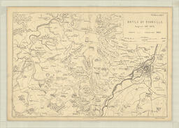
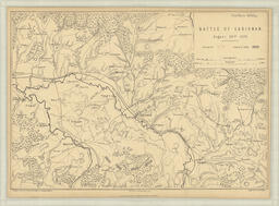
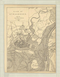
Map depicting Southern Germany and surrounding area. Relief shown by hachures. Shows railway lines. Includes note under title, scale, and brief legend indicating that the territories coloured green are part of the North German Confederation. Comparative lengths for Germany and England are shown along right margin. German land is coloured, with a different colour for each territorial division. One of fourteen maps in this collection from Volume I of Hozier's "The Franco-Prussian War: Its Causes, Incidents, and Consequences". Published circa 1872.
|
||||
Geographic Subject |
Geographic Subject
|
||||
Hierarchical Geographic Subject |
Hierarchical Geographic Subject
Europe
Germany
Southern Germany
|
||||
Extent |
Extent
1 map ; 21.5 x 28 cm on sheet 26 x 36 cm
|
||||
Note |
Note
|
||||
Shelf Locator |
Shelf Locator
260at n.d.(a)
|
Content type |
Content type
|
||||||
---|---|---|---|---|---|---|---|
Collection(s) |
Collection(s)
|
||||||
Title |
Title
|
||||||
Resource Type |
Resource Type
|
||||||
Persons |
Persons
Publisher (pbl): Mackenzie, William
Associated name (asn): Hozier, Henry Montague
|
||||||
Origin Information |
Origin Information
|
||||||
Note |
Note
|
||||||
Physical Location |
Physical Location
W.D. Jordan Rare Books and Special Collections, Queen's University Library
|
||||||
Rights Statement |
Rights Statement
|
||||||
Language |
Language
|
Language |
English
|
---|---|
Authored by | |
Name |
South Germany, (Bavaria, &c.)
|
Authored on |
|
MIME type |
image/tiff
|
Width |
9114px
|
Height |
6827px
|
Media Use |