Insulae Americanae in oceano septentrionali, cum terris adiacentibus.
Image
Insulae Americanae in oceano septentrionali, cum terris adiacentibus.
Content type |
Content type
|
||||
---|---|---|---|---|---|
Collection(s) | |||||
Title |
Title
|
||||
Resource Type |
Resource Type
|
||||
Description |
Description
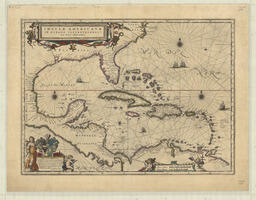
Map depicting Central America, the Caribbean, Eastern Mexico, the Southeastern coast of the United States of America, and the Northern coast of South America. Features illustrations of ships. Includes ornate title cartouche at top left. Ornate cartouche at lower left contains a dedication, signed by Guiljelmus Blaeu, and ornate cartouche near lower right contains scales. Outline, illustrations, and cartouches coloured. Map is the recto side of a double sided document. Published circa 1650.
|
||||
Extent |
Extent
1 map ; 36.5 x 51 cm on sheet 45.5 x 59.5 cm
|
||||
Note |
Note
|
||||
Language |
Language
|
Content type |
Content type
|
||||
---|---|---|---|---|---|
Collection(s) |
Collection(s)
|
||||
Title |
Title
|
||||
Resource Type |
Resource Type
|
||||
OCLC Number |
OCLC Number
39709295
|
||||
Persons |
Persons
Creator (cre): Blaeu, Willem Janszoon
|
||||
Geographic Subject |
Geographic Subject
|
||||
Origin Information |
Origin Information
|
||||
Physical Location |
Physical Location
W.D. Jordan Rare Books and Special Collections, Queen's University Library
|
||||
Shelf Locator |
Shelf Locator
122at 1650
|
||||
Rights Statement |
Rights Statement
|
Language |
English
|
---|---|
Authored by | |
Name |
Insulae Americanae in oceano septentrionali, cum terris adiacentibus.
|
Authored on |
|
MIME type |
image/tiff
|
Width |
14780px
|
Height |
11541px
|
Media Use |